
Wee-cino
Summary
Transport yerself to the Swiss Alps with Scotland's answer to Ticino. The drops arnae as big but the slides are just as fun!
Canyon Descent:
30m
Highest Drop:
11m
Canyon Length:
500m
Minimum Ropes:
x1 40m
Flood Risk:
Low
Access Type:
Public
Rock Type:
Schist
Catchment:
10km2
*No Water Level Indicator
Duration: in, down and out:
IN: 15mins DOWN: 1.5hrs OUT: 15mins
Anchors
Natural
Notes
-
Description
Access: Park in the lay-by on the east side of the bridge over Lawers Burn. Walk up the road pass the houses and follow the path up the munro. When you reach the deer fence do not cross over the stile. Instead, walk along the fence towards the canyon. Cross the fence at the obvious crossing point, and walk uphill for another 100m until the first slide comes into view.
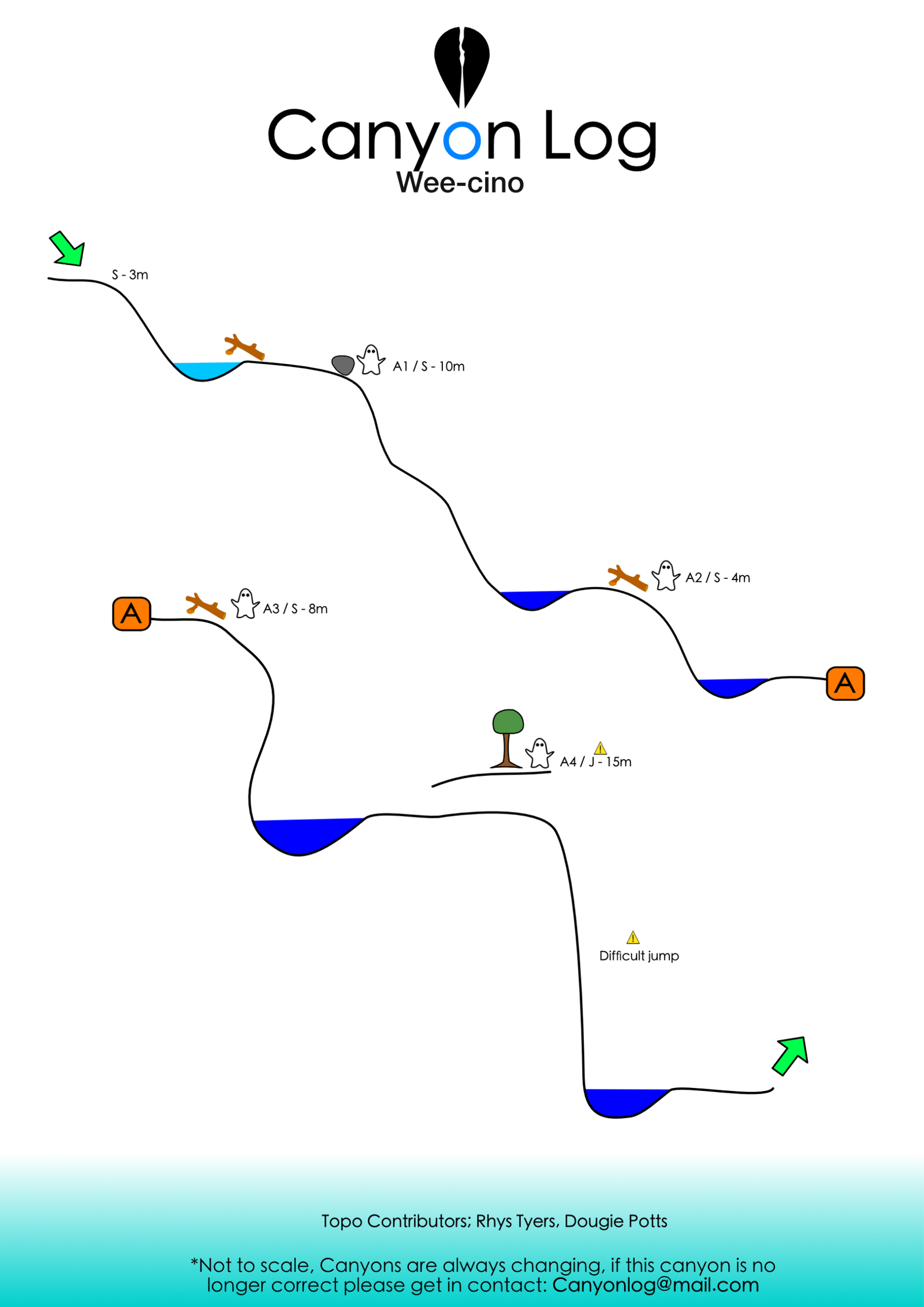
The canyon: Everything goes as a jump or a slide - have fun! The big jump is kinda shallow but has been done many times. Check using the escape rope on RL and make your own mind up.
Escape: After the big jump you can escape back to the path using the rope on RL, or gorge walk down the lower gorge. If you gorge walk, the obvious 3m jump is the best place to escape back to the path.
First Recorded Descent Team
Tessa and Angus!
.


Have You Descended This Canyon Recently?
If so we would love to hear from you in the comment section below! Let the whole community know more about this canyon, Information such as time taken to: approach, descend and exit are extremely helpful, as well as any new hazards you may have come across whilst canyoning at this location.
If any information on this page is missing, incorrect or out of date, please get in contact with us directly so we can rectify as soon as possible.
Disclaimer
No responsibility or liability is taken for any harm, death or loss of property from using the information found on Canyon Log. Topo features, descriptions and notes may not be accurate and could be misleading. You must carry anchor building materials, be experienced and use your own judgement when canyoning. Flooding can completely change the layout, features and conditions. Insufficient experience may result in death.

Supplied a topo and a GPX. The GPX should bring you to the first decent slide which is a low angle one into a pool that currently has an eye gouger log in it. Neither of us lost an eye though. If instead you start as we did at the treeline then you will mostly get slippery gorge walking, though there is one tiny slide and one tiny pitch has an interesting little “cave” under a boulder.
Very high value canyon. I think it would be a classic with some bolts to make checking the pools a bit easier.
Team of two down here this morning. We overshot the entry point and did a bit more gorge walking than planned. Once we found the features its a great canyon with fun slides. Fairly high water today so we used a rope for everything. There’s quite a few trees for anchors. I’d certainly take a rope for this one. The pools all seemed clear but worth a test before sending…. ~40m rope required for the final pitch – the guys who found this canyon and did that pitch as a jump have some serious stones, ill give them that