Water level very low
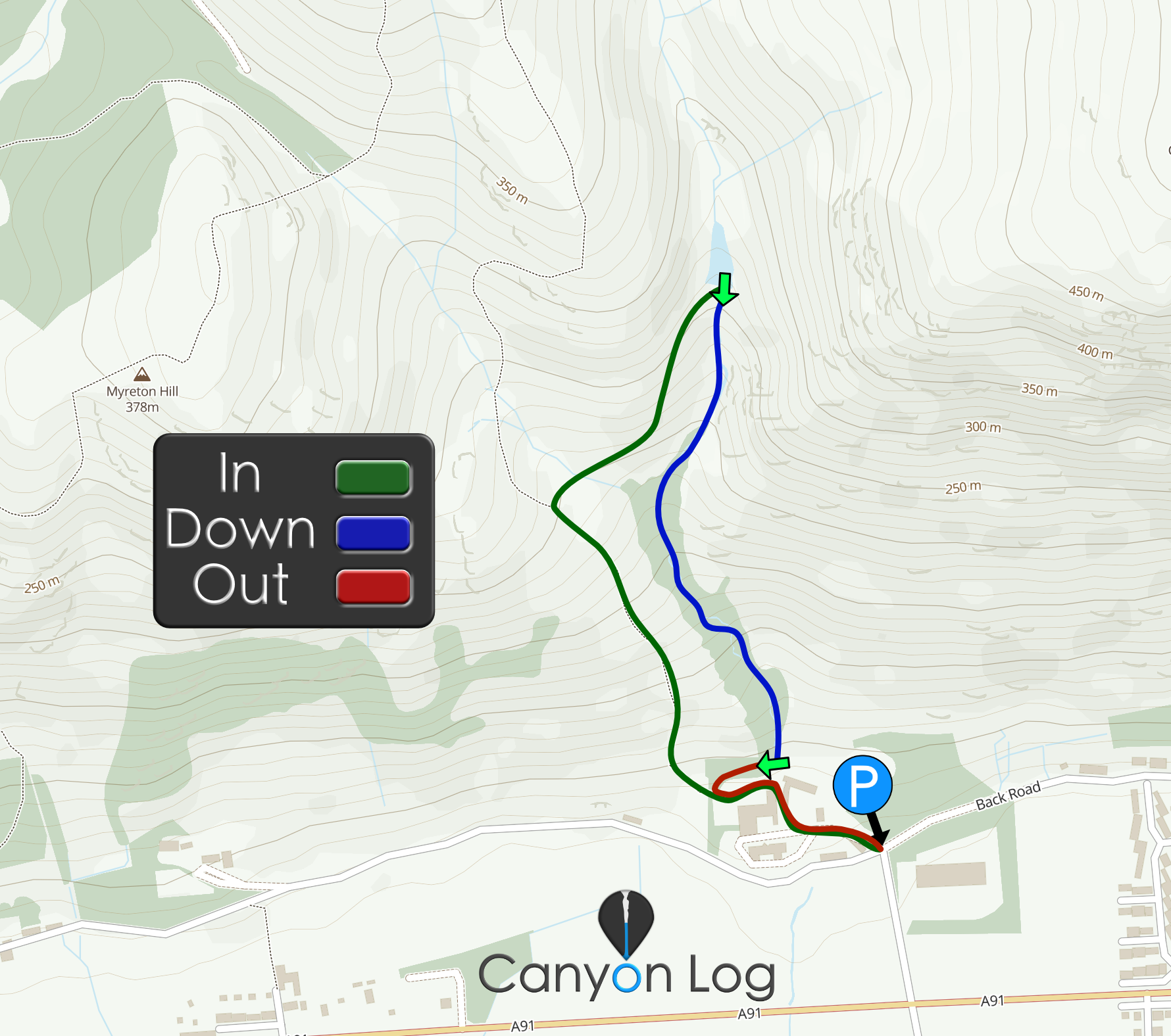
After heading through the building yard, start A very step accent following a very obvious path. Stay on this path until level with the dam then cut across to reach the dam around 260 contour on o.s maps
20m DC using the dam over flow, could be tricky with flow.
If so we would love to hear from you in the comment section below! Let the whole community know more about this canyon, Information such as time taken to: approach, descend and exit are extremely helpful, as well as any new hazards you may have come across whilst canyoning at this location.
If any information on this page is missing, incorrect or out of date, please get in contact with us directly so we can rectify as soon as possible.
DisclaimerNo responsibility or liability is taken for any harm, death or loss of property from using the information found on Canyon Log. Topo features, descriptions and notes may not be accurate and could be misleading. You must carry anchor building materials, be experienced and use your own judgement when canyoning. Flooding can completely change the layout, features and conditions. Insufficient experience may result in death.
Team of 4 last night. Toasty stomp up the hill to the dam to start. The reservoir was completely empty, maintenance work ongoing so the outlet was fully open.
Some fun pitches to start. The enclosed a5 to dc – 4m had some tricky anchor building. There was lots of tat there from previous teams, some had been ripped to shreds as the only anchors are in the flow. The a6 pitch has a log jam behind the chockstone, this makes the anchor build + abseil more challenging. As other teams have commented a few bolts in here, especially in high flow would be very beneficial.
A7 has a good natural anchor high RL with tat in place – we thought the TL anchor could have posed retrieval issues as this pitch twists with trees obscuring the line back to the anchor.
Good outing overall. Long canyon – we were 4 hours car to car and we weren’t hanging about!
Natasha
May 1, 2026 1:54 pm
Canyon Experience :
Team of 2 – In 45m/ down 2h15m / out 10m – bit longer than description. Low levels.
Care needed for anchor selection – few of tree anchors in description now dead and not suitable.
Make sure to bring tat which can be left as some of anchors are underwater.
Oli
September 16, 2025 8:27 pm
Canyon Experience :
Descended today with higher water levels .
Sterling Mills Gauging Station was on 0.77m and dollar and Alva seemed high.
Rope was needed on the first reservoir climb down for support. Some of the downclimbs became pitches .
Wouldn’t do again without drill and bolts as pitches 5-6 we had to make very marginal anchors in the flow.
Lucy Black
September 16, 2025 1:58 pm
Canyon Experience :
Descended on 14/09/25, group of 3, down about 3 hours
Good fun canyon. There had been a lot of rain in the week preceding. Reservoir was almost full, and there was good water flow on all falls, but nothing unmanageable.
All abseils have recently had robust rigging attached to natural anchors. Some simple handlines have been added on some of the down-climbs, which was necessary given the water flow.
Kitt
August 18, 2025 10:04 am
Canyon Experience :
Descended on 17/08/25
Group of 3
In 50 mins, Down 2hrs, out 5
Level pretty much none.
Good canyon. Reservoir at the top was half empty so next to no water in the canyon. A1 anchor on the tree is usable but not ideal as the tree moves. Best avoided. Pools all pretty stagnant. A7 was a very difficult pull down as I think our 8 block got stuck. A 2-1 wouldn’t even pull it free. One of the group had to climb back round to release the rope. A8 was a simple pull down though topo says otherwise. All in all a good canyon but would be better with some flow.
We use cookies to ensure that we give you the best experience on Canyon Log. If you continue to use this site we will assume that you are happy with it.


Team of 4 last night. Toasty stomp up the hill to the dam to start. The reservoir was completely empty, maintenance work ongoing so the outlet was fully open.
Some fun pitches to start. The enclosed a5 to dc – 4m had some tricky anchor building. There was lots of tat there from previous teams, some had been ripped to shreds as the only anchors are in the flow. The a6 pitch has a log jam behind the chockstone, this makes the anchor build + abseil more challenging. As other teams have commented a few bolts in here, especially in high flow would be very beneficial.
A7 has a good natural anchor high RL with tat in place – we thought the TL anchor could have posed retrieval issues as this pitch twists with trees obscuring the line back to the anchor.
Good outing overall. Long canyon – we were 4 hours car to car and we weren’t hanging about!
Team of 2 – In 45m/ down 2h15m / out 10m – bit longer than description. Low levels.
Care needed for anchor selection – few of tree anchors in description now dead and not suitable.
Make sure to bring tat which can be left as some of anchors are underwater.
Descended today with higher water levels .
Sterling Mills Gauging Station was on 0.77m and dollar and Alva seemed high.
Rope was needed on the first reservoir climb down for support. Some of the downclimbs became pitches .
Wouldn’t do again without drill and bolts as pitches 5-6 we had to make very marginal anchors in the flow.
Descended on 14/09/25, group of 3, down about 3 hours
Good fun canyon. There had been a lot of rain in the week preceding. Reservoir was almost full, and there was good water flow on all falls, but nothing unmanageable.
All abseils have recently had robust rigging attached to natural anchors. Some simple handlines have been added on some of the down-climbs, which was necessary given the water flow.
Descended on 17/08/25
Group of 3
In 50 mins, Down 2hrs, out 5
Level pretty much none.
Good canyon. Reservoir at the top was half empty so next to no water in the canyon. A1 anchor on the tree is usable but not ideal as the tree moves. Best avoided. Pools all pretty stagnant. A7 was a very difficult pull down as I think our 8 block got stuck. A 2-1 wouldn’t even pull it free. One of the group had to climb back round to release the rope. A8 was a simple pull down though topo says otherwise. All in all a good canyon but would be better with some flow.