Approach by Car: (Unknown)
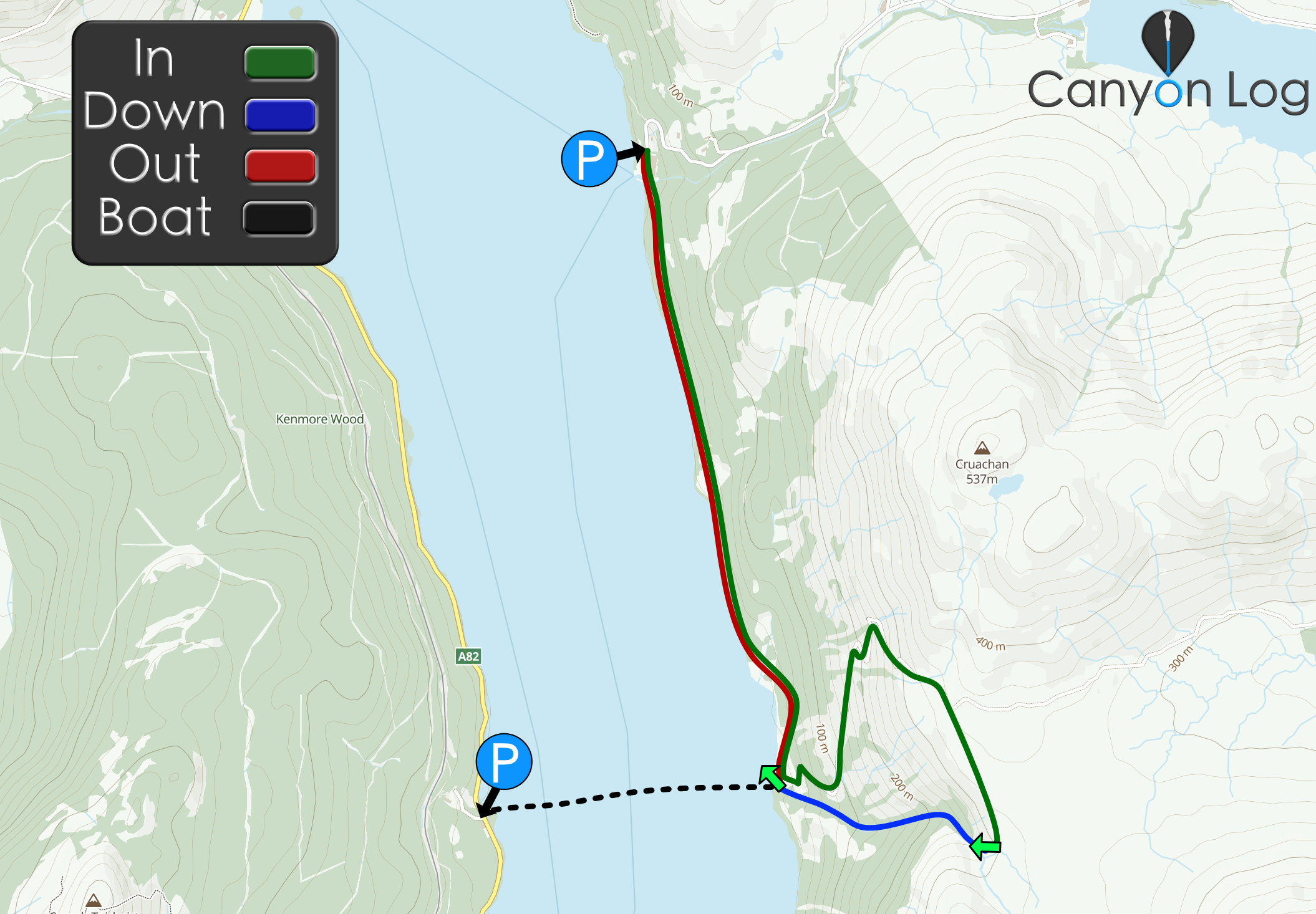
Approach by foot: Boat across the Loch or walk south on the West Highland Way for 3km for Inversnaid. Follow 4wd drive track for about 45mins then head off track until you reach the tributary and follow down to get to the top of the canyon.
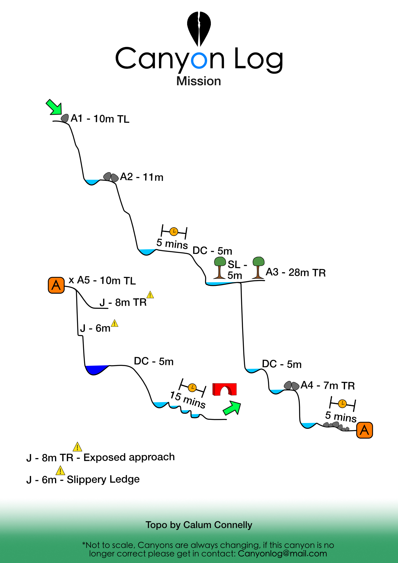
A mix of abseils and down climbs, some down climbs may require a rope in higher flows.
Exit: once you reach the bridge at the end of the canyon.
If so we would love to hear from you in the comment section below! Let the whole community know more about this canyon, Information such as time taken to: approach, descend and exit are extremely helpful, as well as any new hazards you may have come across whilst canyoning at this location.
If any information on this page is missing, incorrect or out of date, please get in contact with us directly so we can rectify as soon as possible.
DisclaimerNo responsibility or liability is taken for any harm, death or loss of property from using the information found on Canyon Log. Topo features, descriptions and notes may not be accurate and could be misleading. You must carry anchor building materials, be experienced and use your own judgement when canyoning. Flooding can completely change the layout, features and conditions. Insufficient experience may result in death.
Descended 26/04/26 team of 2 In low flow.
The previous comment is a god send, the discription is perfect and easy to follow.
Easy ghosting options for missing anchors.
Really fun trip with the paddle in and a decent walk up.
There is also a pop up coffee shop at the bottom of the canyon 😁
Calum Connelly
May 2, 2025 7:59 pm
Canyon Experience :
Descended today in low water conditions. A brilliant trip. Full report below:
Approach last night via Kayak from Blairannaich. Parked van at ///lamenting.drops.yacht
Kayak took roughly 30 minutes at a chilled pace. Waves increased towards the mission side of the Loch on the way there.
Landed kayaks where the canyon meets the loch, river left. Excellent flat and tucked away camping spot just uphill from the West Highland Way path with some ruins which we stored kayaks in during the day. ///cemented.grass.slate
To start the canyon approach walk across the bridge towards Imversnaid past the house and look for the path to your right just before the stream. This quickly joins the track.
Walk up the 4×4 track was steeep. 40 minutes on the track until leaving it at ///approvals.army.anchovies and making our way cross country to the get in on the trib at ///flannel.tortoises.chairs
First abseil is off some webbing river left into a chute. Hard to find webbing at first. We took the dry option off a tree river right.
Anchor was gone for abseil 2. Build a new one river right in a choked boulder on the canyon wall.
Short gorgewalk follows with some fairly chunky downclimbs that would need a rope in higher water.
Next drop was the biggie! Natural anchor off tree river right to start HANDLINE which follows right round the corner to a second tree for a really nice line (next to but out of the flow.)
More gorge walking followed with some trickier downclimbing.
Next abseil from river centre uses a large upstanding boulder. Retrieval appeared to be very difficult after the first person went so we switched to a different anchor river right, making use of a small choke point between boulders.
A gorge walk followed to the last abseil monobolt in good condition. Abseil tricky with a bit of full void at the start. Pool in good condition still and with inspection would be safe for a jump from the slippy shelf half way or from the grass ledge on the right (sketchy traverse to get to this).
The gorge walk at the end took us by surprise. Very long with some technical downclimbing, we were all gorge walked out by the end.
The canyon was probably a 6 out of 10 but making an adventure out of it with the kayak across and camp made is an 8 out of 10 epic canyon adventure.
We use cookies to ensure that we give you the best experience on Canyon Log. If you continue to use this site we will assume that you are happy with it.


Descended 26/04/26 team of 2 In low flow.
The previous comment is a god send, the discription is perfect and easy to follow.
Easy ghosting options for missing anchors.
Really fun trip with the paddle in and a decent walk up.
There is also a pop up coffee shop at the bottom of the canyon 😁
Descended today in low water conditions. A brilliant trip. Full report below:
Approach last night via Kayak from Blairannaich. Parked van at ///lamenting.drops.yacht
Kayak took roughly 30 minutes at a chilled pace. Waves increased towards the mission side of the Loch on the way there.
Landed kayaks where the canyon meets the loch, river left. Excellent flat and tucked away camping spot just uphill from the West Highland Way path with some ruins which we stored kayaks in during the day. ///cemented.grass.slate
To start the canyon approach walk across the bridge towards Imversnaid past the house and look for the path to your right just before the stream. This quickly joins the track.
Walk up the 4×4 track was steeep. 40 minutes on the track until leaving it at ///approvals.army.anchovies and making our way cross country to the get in on the trib at ///flannel.tortoises.chairs
First abseil is off some webbing river left into a chute. Hard to find webbing at first. We took the dry option off a tree river right.
Anchor was gone for abseil 2. Build a new one river right in a choked boulder on the canyon wall.
Short gorgewalk follows with some fairly chunky downclimbs that would need a rope in higher water.
Next drop was the biggie! Natural anchor off tree river right to start HANDLINE which follows right round the corner to a second tree for a really nice line (next to but out of the flow.)
More gorge walking followed with some trickier downclimbing.
Next abseil from river centre uses a large upstanding boulder. Retrieval appeared to be very difficult after the first person went so we switched to a different anchor river right, making use of a small choke point between boulders.
A gorge walk followed to the last abseil monobolt in good condition. Abseil tricky with a bit of full void at the start. Pool in good condition still and with inspection would be safe for a jump from the slippy shelf half way or from the grass ledge on the right (sketchy traverse to get to this).
The gorge walk at the end took us by surprise. Very long with some technical downclimbing, we were all gorge walked out by the end.
The canyon was probably a 6 out of 10 but making an adventure out of it with the kayak across and camp made is an 8 out of 10 epic canyon adventure.